
Review · TUCSON
Mount Lemmon Self-Guided Driving Audio Tour
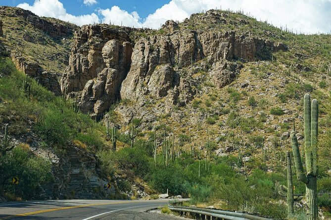
Mount Lemmon changes almost by the minute. You begin among saguaros outside Tucson and climb 6,000 feet toward pine forest, ski slopes, and an old radar site. The location-based audio explains why the scenery shifts so sharply, turning a long uphill drive into a moving lesson in geology, ecology, and local history.
I like the hands-free timing, which starts stories as you reach each point, and the excellent value for a group of up to four. You do need to download the app before leaving strong service, and the narration is designed mainly for the drive uphill, so the return trip can be less useful.
Key points for your Mount Lemmon drive
- More than 44 audio stories cover over 30 miles of the Catalina Highway.
- The scenery changes from Sonoran Desert to alpine country during a 6,000-foot climb.
- GPS-triggered narration plays automatically as you approach overlooks, trailheads, and landmarks.
- The $16.99 price covers one car, making it a low-cost choice for families and couples.
- Offline maps and audio help on a mountain road where cellular service may be unreliable.
- Lifetime access lets you pause, repeat, or use the tour again on another trip.
Why this Mount Lemmon audio tour works so well
Mount Lemmon is best understood as a vertical journey. The Catalina Highway carries you from Tucson’s hot desert floor to an alpine summit, and the route feels like a trip from southern Arizona toward northern forests without leaving the state.
The audio gives that change a clear shape. Instead of seeing saguaros, then grasses, then pines as disconnected scenery, you learn how altitude controls temperature, rainfall, soil, and plant life. At the end of the drive, you have gained about 6,000 feet, enough to create several distinct climate zones.
The Action app uses GPS to trigger each story. You do not need to keep reaching for your phone or stop and restart the audio at every pullout. Several reviews specifically praised the pleasant voice, clear volume, and accurate timing. The key is to follow the route and speed limit. If you get ahead of the narration, the next story may not line up with the view.
This is not a bus tour and nobody meets you at the starting point. You drive your own vehicle, choose your stops, and decide how long to stay. The audio serves as a companion in the passenger seat, which suits this road better than a fixed group schedule.
More Self-Guided Audio Tours in the USA
- Gettysburg Battlefield Self-Guided Driving Audio Tour
★ 4.5 · 910 reviews - Joshua Tree National Park Self-Guided Driving Audio Tour
★ 4.5 · 762 reviews - Ultimate Acadia National Park Self-Guided Driving Audio Tour
★ 4.0 · 521 reviews
Starting among saguaros at Soldier Trail
The tour begins at 9070 East Catalina Highway in Tucson. The first featured stop is Soldier Trail, a challenging five-mile out-and-back hike with about 2,000 feet of elevation gain.
You do not need to hike it for the tour to work. The point of this early stop is to introduce the dry foothills, where saguaros and prickly pear cactus frame the road. If you plan to walk, take the rating seriously. This is not a casual stroll, especially before you have adjusted to the heat.
Next comes Babad Do’ag Scenic Overlook, one of the best early chances to look back across Tucson and the mountains beyond. The nearby trail runs about 4.5 miles and passes saguaros, chollas, and ocotillos. I like this stop because it gives you a city view before the road carries you into wilder country.
Molino Canyon and the first change in plant life
At Molino Canyon Vista, the road reaches roughly 4,000 feet. The desert begins to loosen its grip, and native grasses become more common. You may also see tall ocotillo, desert broom, and pink fairy duster.
The audio uses this area to explain the change in plant life, which is one of the most useful parts of the tour. A scenic overlook is pleasant on its own, but knowing why the vegetation changes makes the climb easier to read.
Molino Basin Trailhead follows. Its five-mile route is relatively flat and works well for walking, running, or mountain biking. It is one of the more approachable trail options along the road, though a five-mile out-and-back still takes time. If you want a short scenic drive with only a few photo stops, keep moving. If you want exercise, this is a good place to build in a break.
Bug Spring and the growing sense of altitude
Bug Spring Trailhead offers a much harder option. The ten-mile out-and-back takes about five hours and climbs roughly 2,000 feet. The route begins in desert foothills, switchbacks toward pine forest, crosses creeks, and finishes near Bear Canyon Picnic Area.
This trail shows the full transition that the drive is explaining. You start among dry desert plants and finish in a cooler, more wooded setting. Still, do not treat the trail as a quick add-on. Its length and climb make it a serious outing, not simply a walk from the car.
Thimble Peak Vista provides a welcome payoff without requiring a long hike. The peak resembles a giant sewing thimble, rising above the canyon at more than 5,000 feet. The shape is easy to recognize, and the audio adds a simple bit of character to the geology.
More Driving Audio Tours in the USA:
- Ultimate Lake Tahoe Self-Guided Driving Audio Tour
★ 4.5 · 435 reviews - Scenic Newport, RI Self-Guided Driving Audio Tour
★ 4.5 · 325 reviews - Arches National Park Self-Guided Driving Audio Tour
★ 4.5 · 288 reviews - Kauai Adventure Bundle: 4 Epic Audio Driving Tours
★ 4.5 · 211 reviews
Waterfalls, picnic pines, and Manzanita Vista
Seven Cataracts is one of the more dramatic natural features on the route. Willow Canyon’s stream drops through a series of cascades covering about 1,000 vertical feet. Despite the name, you may see many small falls rather than seven clean drops.
Water flow can affect how impressive any waterfall looks, so keep expectations flexible. The rock formations and canyon setting remain worthwhile even when the water is modest.
Middle Bear Picnic Area is a practical stop for a sandwich. It sits beside Bear Canyon under ponderosa pines, with views into the canyon and across a slope shaped by erosion and landslides. This is exactly the kind of pause that makes a self-guided tour useful. You can stop for food without worrying about missing a bus departure.
At Manzanita Vista, the focus shifts to the trees themselves. Manzanitas are easy to identify by their smooth red bark and twisted branches. They survive in poor soil with little water, and the audio explains how those conditions shape the grove.
Windy Point and the best single panorama
Windy Point Vista is likely to be a highlight for anyone who wants one broad view of the entire drive. From here, you can look from the Sonoran Desert far below toward the high, cooler summit country.
The view works because it gathers the route into one scene. Earlier, you saw each plant zone arrive gradually. Here, you can understand the whole climb at once. Allow more than a quick glance if the pullout is comfortable and safe, since this is one of the strongest photo stops on the road.
The narration remains useful here because it connects the view to Mount Lemmon’s biodiversity. You are not simply looking at layers of rock and trees. You are seeing how elevation creates several habitats on one mountain.
Hoodoos, Duck Head Rock, and the road’s odd shapes
Geology Vista Point introduces hoodoos, tall narrow rock spires shaped by erosion in dry, hot climates. These formations give the route a different character from the forested sections and show how much of the mountain story is written in exposed rock.
Duck Head Rock is more playful. The formation looks like a duck’s head with a long bill, a simple landmark that breaks up the more technical geology. It is a quick stop, but these memorable shapes help you keep your bearings along a long mountain road.
Hoodoo Vista offers another chance to see the spires. Park at the marked turnout if you want to examine them, or continue if you have already had enough geology stops. The self-guided format makes that choice easy. You can skip a story without holding up anyone else.
Rose Canyon Lake and San Pedro Vista
Rose Canyon Lake adds a surprising note to an Arizona mountain drive: fishing. The lake is described as a quieter stop along the route, so it can be a good place to slow down after the busier viewpoints.
The audio does not turn the lake into a major resort attraction, and that is part of its appeal. You can use it as a calm pause rather than another item to rush through. Entry rules or passes are not included in the tour, so check what you need before planning a fishing stop.
San Pedro Vista looks east toward the San Pedro Valley. It also connects with the Arizona National Scenic Trail, an 800-mile route running from the Mexican border to Utah. You do not need to hike beyond the viewpoint. The detail simply shows how this short drive links with a much larger network of trails.
If you need a restroom, the route points you toward the Palisades Visitor Center by way of East Organization Ridge Road. That small bit of practical guidance matters on a two to three-hour mountain drive, especially if you are traveling with children.
Butterfly Trail and the crashed fighter jet
Butterfly Trail is an 11-mile challenge, but its unusual attraction appears about three miles in. An unofficial side path leads to a crashed F86 fighter jet from 1957.
That story gives the trail a sense of mystery, though you should not confuse an unofficial route with a marked attraction. The tour provides the lead, but the hike remains long and demanding. If you are not prepared for an 11-mile outing, enjoy the information from the car and continue to the next viewpoint.
The audio is strongest when it mixes these odd details with the larger natural story. A fighter jet wreck, a duck-shaped rock, and a Cold War radar station give the drive human scale. You remember them more easily than a list of elevations.
Aspen Vista, Red Ridge, and the alpine zone
Aspen Vista sits near 8,000 feet and offers a wide view on a clear day, possibly reaching about 50 miles. Across the valley are the Galiuro Mountains, another sky island range separated from Mount Lemmon by a deep valley and the San Pedro River.
This is where the drive feels farthest from Tucson. The temperature is cooler, the air feels thinner, and the trees and open views replace the cactus country below. Weather can change the quality of the view, so treat the 50-mile sightline as a clear-day possibility rather than a promise.
Red Ridge Trailhead gets its name from the red soil underfoot. The color comes from iron-bearing minerals that weather and rust. The trail is a moderate ten-mile route, so it is best suited to visitors who deliberately want a full hike rather than a quick walk.
Ski Valley and the Cold War radar station
Mount Lemmon Ski Valley provides the road’s most unexpected change in use. This is an alpine mountain with a ski resort, a sharp contrast to the cactus and desert heat below.
The tour ends near Mount Lemmon SkyCenter Observatory at 9800 East Ski Run Road. The final stories explain that the site first served a military purpose. In 1956, during the Cold War, the government built a radar station to scan for enemy aircraft and missiles. It operated as the world’s highest continually operating radar station for ten years, with about 80 men living and working there.
That history gives the summit more weight than a simple scenic endpoint. The mountain was valued not only for its views and snow, but also for its height and strategic position.
Price, timing, and how to get the best value
The price is $16.99 per group of up to four people. That is the strongest financial argument for this tour. A family or group can split the cost across one car, making it much cheaper than a private guide or organized vehicle tour.
The stated drive takes about two to three hours, but the route covers more than 30 miles and includes over 44 stories. Add time for viewpoints, lunch, restroom stops, weather, and any hike, and your outing can easily take much longer.
Download the Action Tour Guide app and the tour before you reach the mountain. You receive setup instructions and a password by email and text, then enter the password in the separate app. Strong Wi-Fi or cellular service is required for the download, but the tour works offline afterward.
Connect your phone to the car stereo by Bluetooth, USB, or AUX. Apple CarPlay is supported, while Android Auto support is still being added. An iPhone running iOS 15 or later, an Android device running version 9 or later, or a GPS-equipped tablet with cellular access is recommended.
One important caution: the tour is built around the uphill route from Tucson toward Mount Lemmon. The audio may be confusing on the way down, and one review noted that the app could point out a pullout just after the car had passed it. If you miss a stop, avoid making a sudden turn. Continue safely and use the tour again another time if needed.
The product includes lifetime access with no expiry. You can pause it, repeat it, or use it on another trip. The cancellation policy allows a full refund when you cancel at least 24 hours before the scheduled start time. Changes or cancellations within 24 hours are not refunded.
Who should book this self-guided drive
I recommend it most to first-time Mount Lemmon visitors who want context without joining a group. It also suits families, couples, and friends sharing one car, especially if everyone wants the freedom to stop for photos or food.
It is less suitable if you want a live guide answering questions in real time, or if you plan to drive mainly downhill. It also cannot replace careful mountain-road driving. Keep to the speed limit, watch for pullouts, and let the narration fit around your attention to the road.
Should you book the Mount Lemmon audio tour?
Book it if you want a low-cost way to understand the road while keeping control of your day. The strongest features are the accurate GPS timing, pleasant narration, offline access, and the way the stories connect cactus country, pine forest, geology, hiking, and Cold War history.
Skip it if you prefer complete silence, a traditional guide, or a fixed list of short stops without optional hikes. For most people sharing a car, $16.99 is a small price for a route that can otherwise feel like a series of disconnected pullouts. Download it before leaving Tucson, drive uphill at a steady pace, and give yourself more than the minimum two hours if you want to stop often.
FAQ
How long does the Mount Lemmon audio tour take?
The driving portion takes about two to three hours. Stops for photos, food, restrooms, fishing, or hiking will make the outing longer.
Where does the tour begin and end?
It begins at 9070 East Catalina Highway in Tucson and ends near Mount Lemmon SkyCenter Observatory at 9800 East Ski Run Road, Mount Lemmon.
Does the tour work without cell service?
Yes. You must download the tour while connected to strong Wi-Fi or cellular service. After downloading, the maps and audio work offline.
How many people can use one purchase?
One purchase covers a group of up to four people in the same vehicle.
Does the tour include attraction tickets or reservations?
No. Attraction passes, entry tickets, and reservations are not included.
Can I use the tour more than once?
Yes. The tour provides lifetime access with no expiry, so you can pause it, repeat it, or use it again on another trip.
New audio tours around the USA
- Beaches, Bites and Bavaria in Leavenworth: A Self-Guided Audio Tour★ 3.5 · 3 reviews
- Welcome to Fabulous Las Vegas Sign Self-Guided Audio Tour★ 5.0 · 2 reviews
- Las Vegas Day Trips: 3-Day Self-Guided Audio Tour★ 5.0 · 2 reviews
- Hoover Dam and Lake Mead Self-Guided Audio Tour★ 5.0 · 3 reviews
- Driving Lake Tahoe: A Self-Guided Audio Tour From Tahoe City to Incline Village★ 5.0 · 10 reviews
- Las Vegas Neon and Secrets: Self-Guided Audio Tour★ 5.0 · 3 reviews
- Baton Rouge Historic Downtown Self-Guided Audio Walking Tour★ 4.0 · 19 reviews
- Ultimate La Jolla Self-Guided Driving & Walking Audio Tour Bundle★ 3.5 · 9 reviews
Tucson Audio Tours, compared.


Downtown Tucson: An Audio Tour by an Author and Historian
Read our review →
Saguaro NP and Mt. Lemmon Self Guided Driving Audio Tour Bundle
Read our review →Browse the lists this tour appears in